Urban Watershed Framework Plan: A Reconciliation Plan For Conway
University of Arkansas Community Design Center
Landscape
/
Future
Project Description
The Framework Plan shows that repair of degraded urban watersheds can be a powerful agent for reinventing the physical environments of post-industrial cities. More than half of America’s waterbodies are unsafe for swimming, fishing, and as sources of drinking water due to anthropogenic activity. Considering that city and watershed generate conflicting shape and structure across the landscape, how can city form fix the watershed to deliver ecosystem services? The Plan pioneers an innovative developmental vocabulary for universal application in “wet” cities, showing what a comprehensive design-based urban watershed plan looks like. The Plan introduces watershed management principles into urban design for a fast-growing city with severe water management problems. The project invents a transferable planning vocabulary aligning the city’s metabolism with that of the watershed. A portfolio of modulated green infrastructural retrofits provides value-added work to conventional urban infrastructure investments. Green infrastructure, incorporating urban rain terrains (holding water) and riparian corridors, delivers ecosystem services benchmarked to the Ecosystem Services Concept, a matrix of 17 ecological services delivered through higher-order transformations of degraded ecosystems.
Aligning Urban and Ecological Metabolism
The Framework Plan is one part in a multi-pronged initiative by the EPA and the Arkansas Natural Resources Commission to mitigate severe urban water management problems in the Little Creek-Palarm Creek sub-watershed incorporating the City of Conway, Arkansas (pop. 62,500). Conway, the state’s second fastest growing city in the nation’s 75th fastest growing county, resides within a designated Priority Watershed. The sub-watershed drains approximately 42 square miles and contains five polluted urban headwater streams exhibiting advanced urban stream syndrome. The immediate goal is the removal of these streams from the Arkansas Department of Environmental Quality 303(d) list of impaired water bodies. Urban sedimentation and stormwater runoff are contributing to the continued decline of Lake Conway downstream. A major natural and economic asset to the area, Lake Conway at 6,700 acres is the largest reservoir in the U.S. built by a game and fish commission. Since Conway averages 51” of rainfall annually—30% more than the national average—the Framework Plan reconciles urban growth with a green infrastructure incorporating urban rain terrains (based on holding water) and riparian corridors (based on drainage). Rather than limit downtown Conway’s current growth and push growth further out, the goal of the Framework Plan is to equip urban infrastructure and land uses to deliver the 17 ecosystem services found in all healthy ecosystems, including regulation of flooding and water pollution. Collateral benefits of reconciliation between city and watershed include greater livability, sustained economic development, improved community resilience to disruption and shocks, and a civic landscape that expresses enduring environmental value. Project sponsors wanted a transferable and scaled planning vocabulary for application in city-watershed interface planning elsewhere.
A Transferable Urban Design Vocabulary for Resilience
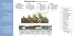
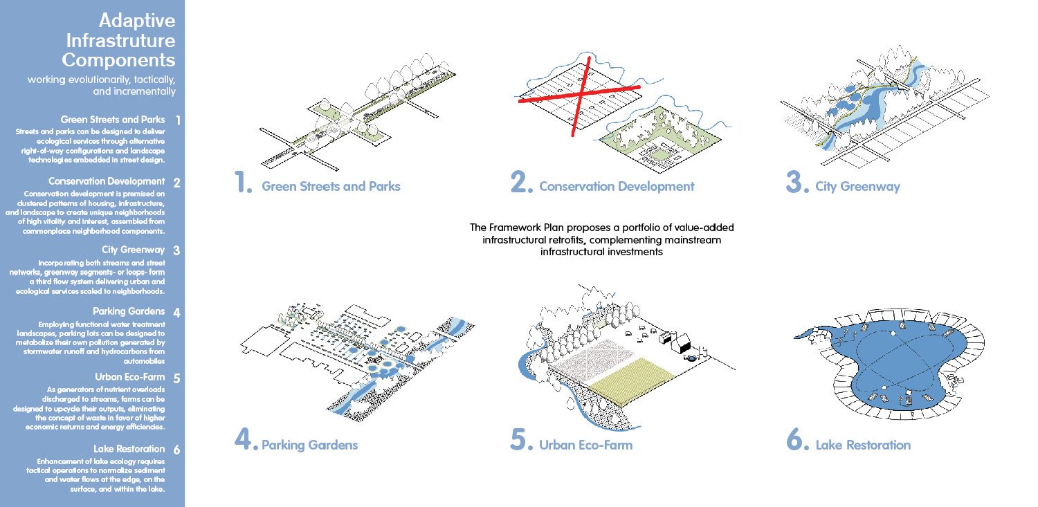
The Framework Plan’s design tools and planning vocabulary provide communities with a transferable resilience framework to restore urban watersheds though urban design. The challenges in implementing resilience or risk-based decision-making in urban systems include the lack of a common language of assessment and management for the characteristics that makes those systems resilient. We need a language of resilience design and management that aligns with the language of city ordinances and policies. The Plan employs the Ecosystem System Services Concept and the 17 ecological services provided by healthy ecosystems to improve the ability of communities to remedy stressors that adversely affect the resilience of urban systems. The team developed a Sponge City Gradient, a Water Treatment Technologies Spectrum, and Six Adaptive Infrastructure Types.
Given the challenge of funding, political will, and complexity, the Plan operates evolutionarily through a set of Adaptive Infrastructure Types that are incremental, contextual, and successional. These value-added infrastructural retrofits—green streets, water treatment art parks, urban eco-farms, conservation neighborhoods, parking gardens, riparian corridor improvements, lake aerators, vegetative harvesters and floating bio-mats, and a city greenway—complement mainstream infrastructural investments. The approach builds a cityscape expressive of the city’s desire for a green stormwater utility that creates a place-based open space system.
The Sponge City Gradient formulates planning interfaces between land use characteristics and hydrology shaping the Framework Plan. Opportunities are configured according to prevailing development profiles shaping downtown, suburban, exurban, and rural sectors. Pixelation works within fragmented land-starved downtown landscapes. Nesting engages the pulsed frequencies of activity in parking lots and other large commercial sites. Clustering is an ideal pattern language for land-rich development. Connection in rural areas and along riparian corridors continues the imperative of large scale natural systems to connect.
The City has secured funding to implement demonstration projects of the city greenway and a new town square as a rain terrain. The town square site just completed brownfield mitigation and hydrological modeling through an EPA Brownfields Cleanup Grant in 2018, and development of the square is underway. The City adopted the Low Impact Development codes developed by the project team.
/28
Streets and Parks: reedy plant guilds are ideal for erosion and water control.
University of Arkansas Community Design Center
Town Square: infiltration mounds provide regulating services and manage stormwater.
University of Arkansas Community Design Center
Town Square: underground filtration basins filter sediment and infiltrate stormwater.
University of Arkansas Community Design Center
Town Square: designed as a bio-retention mat to hold floodwater during storms.
University of Arkansas Community Design Center
Parking Garden: a tree-lined sediment filter improves water quality and tree health.
University of Arkansas Community Design Center
Reclaimed Water Treatment Plant: provides water quality regulating and provisioning.
University of Arkansas Community Design Center
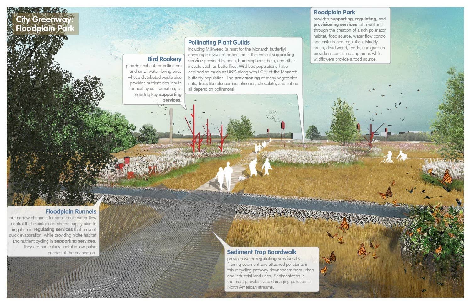
Floodplain Park: is a wetland that provides rich pollinator habitat and water flow control.
University of Arkansas Community Design Center
City Greenway: the urban floodplain meadow provides regulating services by reducing water velocity.
University of Arkansas Community Design Center
Wetland Preserve: the restored riparian corridor functions as wildlife movement corridor/habitat.
University of Arkansas Community Design Center
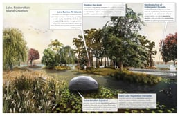
Lake restoration: island creation through floating bio-mats provides water treatment services.
University of Arkansas Community Design Center
Cities are fragmented while watersheds are continuous; four city-water interfaces shape place.
University of Arkansas Community Design Center
The watershed expressed through hydrological units begins an urban design strategy.
University of Arkansas Community Design Center
Conway’s waterbodies are impaired—unsafe for swimming, fishing, and as drinking sources.
University of Arkansas Community Design Center
The Plan formulates three Planning Tools key to watershed urbanism.
University of Arkansas Community Design Center
Urban form can fix the watershed using value-added infrastructure sets.
University of Arkansas Community Design Center
In the downtown use rain terrains rather than drainage to manage water and flooding.
University of Arkansas Community Design Center
Use soft-engineered remediation gardens in existing hard-engineered infrastructure.
University of Arkansas Community Design Center
Reprogram settlement patterns—like subdivisions—as sponge cities to manage water on-site.
University of Arkansas Community Design Center
Restore the component critical to hydrologic functioning but eliminated by urbanism—floodplains.
University of Arkansas Community Design Center
The Pollinator Garden merges floodplain with pollination, public art, and habitat construction.
University of Arkansas Community Design Center
Boardwalks double as water management infrastructure regulating flow and sedimentation.
University of Arkansas Community Design Center
Restore wetlands and their holding capacity as a hydrological foyer to Lake Conway.
University of Arkansas Community Design Center
Slow, soak, and spread water: building a network without channelization that maximizes drainage.
University of Arkansas Community Design Center
Green the parking lot, so that our single largest land use can deliver ecosystem services.
University of Arkansas Community Design Center
Retrofit the industrial farm as a permaculture landscape for sustainability and higher yields.
University of Arkansas Community Design Center
Re-oxygenate the lake to restore water flow and aquatic life endangered by sedimentation.
University of Arkansas Community Design Center
Use ancient and contemporary robot technologies to restore lake equilibrium.
University of Arkansas Community Design Center
Like ancient wetland farmers, build islands from sediment to provide fish and fowl habitat.
Conway, Arkansas
United States
City of Conway, Arkansas
100000 mq
Jeffrey Huber, AIA; Allison Lee Thurmond Quinlan, AIA, ASLA; Cory Amos, AIA; Jessica Hester, AIA; Claude M. Terral III, AIA
Stephen Luoni, Director; Mathew Hoffman; Francisco Mejias Villatoro; David Jimenez; Tanzil Shafique; Kay Curry, Landscape Designer; Jay Williams; Jonathan Martinez; Robert Quinten McElvain
University of Arkansas Department of Biological and Agricultural Engineering and Office for Sustainability; Scott Grummer, City Planner
University of Arkasnas Community Design Center
Curriculum
The University of Arkansas Community Design Center is an outreach center of the Fay Jones School of Architecture and Design, and one of a few university-based teaching offices in the United States dedicated to delivering urban design work. Originated in 1995, the center advances creative development in Arkansas through design, research, and education solutions. Nationally recognized in public-interest design, the center has its own downtown facilities and 5-6 professional design/planning staff, some who also teach. Beyond the focus on urban projects, UACDC has developed eight place-making platforms to shape civic design and public policy at state and municipal levels. These interdisciplinary platforms include 'missing middle housing,' 'agricultural urbanism,' 'transit-oriented development,' 'context-sensitive street design,' 'watershed urbanism,' 'big box urbanism,' 'smart growth,' and 'low impact development,' vocabularies which are locally articulated but hold universal currency.